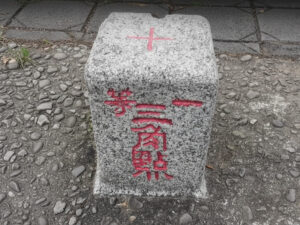
What are the ‘Lesser 100 Peaks’? What to Know Before You Go
The Taiwan Lesser 100 Peaks project (臺灣小百岳) was initiated by the government in 2003 to promote hiking for all, making it the perfect starting point for beginner hiking in Taiwan. The selection criteria focus on “accessibility,” choosing 100 representative peaks perfect for day hikes near urban areas, with relatively clear hiking trails.
This list is not static; it is dynamically adjusted based on actual trail conditions and feasibility to ensure the system’s utility and safety. Therefore, when planning your trip, you should not only confirm whether your route requires a permit via the “Online Application for Taiwan National Park Permits” but also check the official announcements on the “Taiwan Forest Recreation” website for the latest trail information.
Regional Mountain Analysis & Data
Northern Region
| Mountain (No.) | City/County | Elevation (m) | Difficulty | Time (Hrs) |
|---|---|---|---|---|
| Qixing Mt. Main Peak (002) | Taipei City | 1,120 | T2 (★★) | 1.5 – 3.0 |
| Guanyin Mt. (005) | New Taipei | 616 | T1 (★) | 2 – 3 |
| Jilong Mt. (006) | New Taipei | 588 | T1 (★) | 1.5 – 2.5 |
| Yuan Mt. (019) | New Taipei | 321 | T1 (★) | 0.5 – 3.0 |
Qixing Mountain Main Peak (七星山主峰)
Key Features: Notable post-volcanic activity, including fumaroles and sulfur crystals.
Difficulty Analysis: Well-maintained trail with a steady incline. Rated as easy to moderate.
Guanyin Mountain (觀音山)
Key Features: Volcanic terrain with large lava rock formations. Great views of the Tamsui River estuary.
Difficulty Analysis: Mostly stone steps, well-equipped trail. An easy suburban hike, perfect for beginners.
Jilong Mountain (基隆山)
Key Features: A landmark of Jiufen. Covered with silver grass in autumn. Offers 360-degree ocean and mountain views.
Difficulty Analysis: An easy trail composed mainly of well-maintained stone steps.
Yuan Mountain (鳶山)
Key Features: Features a unique “Rainbow Wall” rock formation along the traverse route.
Difficulty Analysis: The main peak is easy. The traverse route includes rugged paths and rope-assisted climbs, raising the difficulty to moderate.
Central Region
| Mountain (No.) | City/County | Elevation (m) | Difficulty | Time (Hrs) |
|---|---|---|---|---|
| Jiali Mt. (034) | Miaoli | 2,220 | T3 (★★★) | 7 – 8 |
| Huoyan Mt. (035) | Miaoli | 602 | T2 (★★) | 3 |
| Toukoushan (041) | Taichung | 859 | T2 (★★) | 4 – 5 |
Jiali Mountain (加里山)
Key Features: Dense cedar forests and remnants of old logging railways.
Difficulty Analysis: Moderate to difficult. Significant elevation gain and a steep final section requiring scrambling and ropes. Not for beginners.
Huoyan Mountain (火炎山)
Key Features: A classic badlands landscape with spectacular eroded gullies and cliffs.
Difficulty Analysis: Easy to moderate. Some narrow ridges and loose gravel require caution.
Toukoushan (頭嵙山)
Key Features: Known for its unique log trails built to protect the terrain.
Difficulty Analysis: Moderate. The log trails are challenging for balance, leg strength, and knees.
Southern Region
| Mountain (No.) | City/County | Elevation (m) | Difficulty | Time (Hrs) |
|---|---|---|---|---|
| Duli Mt. (060) | Chiayi | 816 | T1 (★) | 2.5 – 3.5 |
| Weiliao Mt. (073) | Pingtung | 1,427 | T2 (★★) | 6 – 8 |
| Lilong Mt. (079) | Pingtung | 1,062 | T2 (★★) | 5 – 8 |
Duli Mountain (獨立山)
Key Features: Integrated with the Alishan Forest Railway, which spirals around the mountain three times.
Difficulty Analysis: Easy. The trail consists of well-maintained stairs with a gentle slope, a popular choice for family outings.
Weiliao Mountain (尾寮山)
Key Features: The latter part of the trail features a pristine forest with rich mid-elevation flora.
Difficulty Analysis: Moderate to difficult. The challenge lies in the long distance (18km round trip) and over 1200m elevation gain, requiring excellent stamina.
Lilong Mountain (里龍山)
Key Features: The highest peak on the Hengchun Peninsula, offering views of the Taiwan Strait.
Difficulty Analysis: Moderate. The trail is continuously steep, and the hot, humid climate makes it physically demanding.
Eastern Region & Outlying Islands
| Mountain (No.) | City/County | Elevation (m) | Difficulty |
|---|---|---|---|
| Sanjiaolun Mt. (083) | Yilan | 1,029 | T2 (★★) |
| Kalabao Mt. (086) | Hualien | 2,397 | T3 (★★★) |
| Dulan Mt. (093) | Taitung | 1,190 | T2 (★★) |
| Taimali Mt. (094) | Taitung | 1,337 | T1 (★) |
| Hongtou Mt. (097) | Lanyu | 552 | T2 (★★) |
Sanjiaolun Mountain (三角崙山)
Key Features: Famous for the “Matcha Mountain” view, with its summit covered in arrow bamboo.
Difficulty Analysis: Moderate. The final section is a steep, slippery climb requiring ropes.
Frequently Asked Questions (FAQ)
Further Reading
- Our Articles: Taiwan hiking Culture: The Mountaineering Spirit from the 100 Peaks to the Small 100 Peaks, Taiwan’s 100 Peaks: A Complete List and Hiking Guide
- Wikipedia: List of Lesser 100 Peaks of Taiwan
- Official Info: Taiwan Forest Recreation – Provides real-time trail announcements, status reports, and safety information. A must-visit site for trip planning.