An essential guide to Taiwan’s Triangulation Points, designed for foreign visitors. Learn about their grade differences, the mountain summit ritual, function, and historical importance to enhance your hiking knowledge and ensure a respectful journey.
In-Depth Analysis: The Triangulation Point
History, Function, and Significance
The Triangulation Point (三角點), also known as a Taiwan Survey Marker, is the cornerstone of the island’s geographic history. They were first established during the Japanese rule (1895-1945) to serve as reference points for triangulation. Their original purpose was to create accurate maps, determine peak elevations, and demarcate land ownership boundaries. For modern hikers, finding one represents the highest meaning of a successful summit—a unique ritual connecting them to Taiwan’s geographical past.
Appearance and Structure
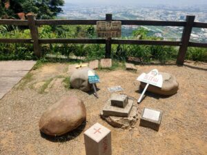
A triangulation point is typically a square or cylindrical pillar made of cement or granite, buried in the ground with only the top surface exposed. The top is engraved with a clear crosshair to precisely mark the central point. The sides of the pillar are inscribed with the point’s grade (First, Second, or Third Order) and a unique number for identification.
Current Use and Special Significance
While modern surveying primarily uses GPS, triangulation points remain crucial as important historical relics and on-site verification markers. For hikers, finding one is the official proof of completing a peak challenge, symbolizing a link to the land’s history. Locating it means you have reached the mountain’s most precise geographical location.
Geodetic Marker Photo Reference
Below are examples of the markers’ physical appearance. Please replace the links with your own image URLs.


*Images are placeholders; please replace `src` links with your actual image URLs.
Triangulation Point Grades (等級差別)
Click the tabs below to view detailed explanations and functions of the different survey marker grades.
First Order Triangulation Point (National Standard)
The highest grade, serving as the foundation of the entire national survey network. Due to their strict placement requirements (often highest peaks with excellent visibility), they are the rarest. They typically sit atop major, high-altitude mountains.
Function: Used to establish the national geographic information system.
Marker Feature: Stone pillar with a prominent crosshair on top and “First Order” inscribed on the side.
Video Tutorial: How Triangulation Points & GPS Calculate Distance
The Significance and Summit Ritual
The Triangulation Point is not just a geographic marker; it’s the unique cultural ritual that proves success and completion within Taiwan’s hiking tradition.
What is the “Summit Ritual”?
In Taiwan’s hiking culture, the true summit ritual is not simply reaching the highest elevation, but rather “finding the Triangulation Point.” Since the marker represents the mountain’s most precise geographical location, hikers often queue to take a photo with it. This picture serves not only as proof of personal achievement but also as a tribute to the land’s surveying history. For those completing challenges like the Hundred Peaks, collecting these marker photos is the crucial final step in documenting their journey.
Hike the Trail
Reach Summit
Locate the Marker
Take Photo Proof
Taboos and Legends: Respect for the Mountain
🚫 Do Not Step or Sit
This is the most critical taboo. The Triangulation Point is a precision reference marker; any weight or pressure can cause tiny shifts in the foundation, affecting national geographic accuracy. Always take your photos standing next to it.
🚨 Do Not Damage or Vandalize
The geodetic marker is state property and carries legal status. Damaging or vandalizing it is not only disrespectful to the surveyors’ history but may also be subject to prosecution. Leave the marker in its original condition.
🙏 Respect the Spirits & Leave No Trace
Many summits are considered the abode of Mountain Spirits or earth gods. After the summit ritual, maintain quiet respect, offer silent thanks for a safe journey, and strictly adhere to Leave No Trace principles.
Frequently Asked Questions (FAQ)
What is the difference between a Triangulation Point and the summit elevation?
The Triangulation Point is a survey marker that records precise coordinates within the geodetic system. The summit elevation refers to the highest physical altitude. They are often in the same location, but the marker might be placed a few meters away from the absolute highest point due to specific requirements for surveying (e.g., clear visibility).
Does the grade of a Triangulation Point affect hiking difficulty?
Not directly. The grade (First, Second, Third Order) only represents the precision and spacing of the marker in the surveying network, and has no direct relation to hiking difficulty. However, First Order points are typically placed on the **highest, most prominent peaks**, indirectly suggesting a high-altitude challenge (like the Major Hundred Peaks).
Why is it forbidden to step on a Triangulation Point?
This is primarily due to scientific respect and legal protection. The marker is a national geodetic reference; standing on it could cause minute shifts in the foundation, destroying the accuracy of its geographic coordinates. Furthermore, damaging or moving a state survey marker is illegal.
What should I do if I cannot find a Triangulation Point on the summit?
Sometimes the marker may be covered by plants, soil, or have fallen due to natural causes. If you cannot find it, do not dig or disturb the surrounding environment. Modern hikers often rely on GPS to confirm their location. The priority is always a safe ascent and descent; finding the marker is secondary.